
|
Extreme Wind Speed Data Sets: Hurricane Wind Speeds |
|
| Data Origin | This section contains data sets of simulated 1-minute hurricane wind speeds at 10m above ground in open terrain near the coastline. For details, see M. E. Batts, E. Simiu and L. R. Russell (1980), "Hurricane Wind Speeds in the United States," Journal of the Structural Division, Vol. 106, Issue 10, pp. 2001-2016. |
| Structure of the Data Files |
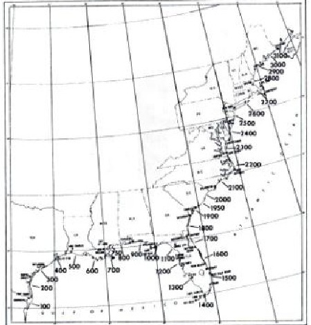
There are 55 files with data for
locations ranging from milepost 150 (near Port Isabel, TX)
to milepost 2850 (near Portland, ME), spaced at 50 nautical
mile intervals. The structure of each data file is as follows:
The final number (18th) number in each line is the storm identifier (see the map).
|
| Location Map |

Locator map with coastal distance intervals (mileposts) marked, in nautical miles. From F. Ho, R. Schwerdt, and H. Goodyear, Some Climatolgical Characteristics of Hurricanes and Tropical Storms, Gulf and East Coasts of the United States, NOAA Technical Report NWS 15, Washington, DC, 1975. |
| Available Datasets |
The following is the list of simulated hurricane data sets.
|
|
Date created: 05/02/2005 |
|